Description
Directions
Viewing Information
- CL-R-16 and CL-R-17 - Medium A Density Residential Development (20 - 50 acres per ha) to include a mix of house types.
- Metropolitan Greenbelt Area.
Show more...
| Beds | |
| Price | Sale Agreed |
| Property Type | Development Land |
| Size | 0 meters2 |
| Energy Rating | BER- |
| Refreshed on | |
| Eircode | |
| Group Name | Savills Commercial Cork |
| Sales License Number | 002233 |
Description
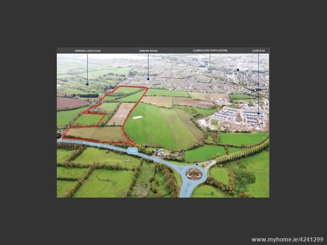
Located in the highly sought after town of Carrigaline. Only 6.5km from Douglas Village and 12km from Cork City Centre. The site extends to approximately 13.74 hectares (33.94 acres) in total. Approximately 9.31 hectares (23 acres) zoned "Medium A Density Residential Development". Location provides ease of access to and from Douglas/Cork City via the N28. Potential to develop a high quality scheme in the region of 230-325 units.
Directions
Location: The subject property is located on the city side of Carrigaline Town Centre and approximately 6km south east of Douglas Village. The site sits between Fernhill Golf Club, located immediately to the east and the ongoing Janeville development located immediately to the west. Carrigaline is recognised largely as a commuter town located approximately 12km south of Cork City. The population of the town has expanded progressively over the past 10-15 years and was estimated at 15,770 persons in the 2016 Census. The town contains mainly estate type housing and the retail offering in the town includes local shops and larger retail operators such as SuperValu; Dunnes Store and Lidl. Large employers in the wider Carrigaline/Ringaskiddy area include Pepsi, Unilever, Glaxo Smithkline, Biormartin, Pfizer and Novartis. Excellent educational facilities are provided locally as well as a range of sporting clubs and leisure facilities.
Viewing Information
Description: The site consists of undeveloped lands extending to approximately 13.74 hectares (33.94 acres) in total, located just off the Shannon Park Roundabout approximately 1.5km north of Carrigaline Town Centre. Of the entire landholding the net developable area extends to approximately 9.31 hectares (23 acres ) which excludes the required provision of a linear open space (CL-O-09) and greenway along the old rail line (CL-U-05) as per the Carrigaline Local Area Plan. Zoning: Under the Ballincollig Carrigaline District Local Area Plan 2017 the land is zoned as follows:
Date created: May 24, 2018